


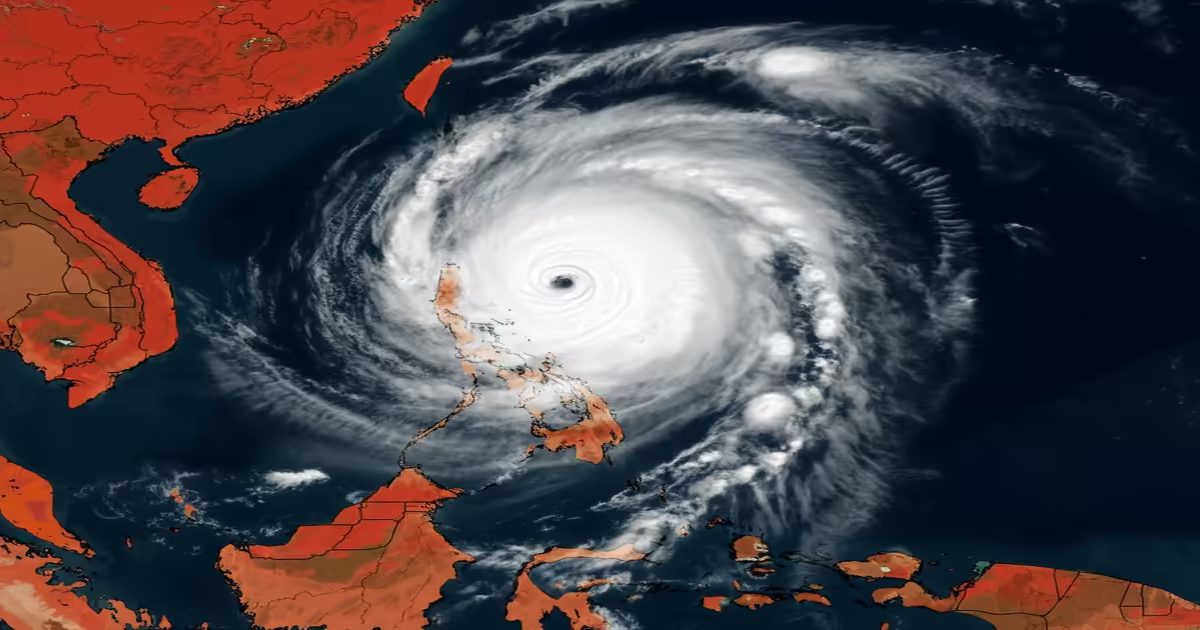
On Wednesday night, a tropical depression in the South China Sea developed into Typhoon Co-may, marking the eighth typhoon of the year. By Thursday, Co-may was located close to the seventh typhoon, Francisco, sparking concerns about the Fujiwhara effect—a unique meteorological occurrence where two nearby tropical cyclones can influence each other’s paths, possibly leading to their merging.
The name Co-may, translating to a type of grass in Vietnamese, is being introduced this season to replace the retired name Lekima. Forecasts suggest that Co-may will move southward initially before taking a northeast turn, aiming towards the northwestern coast of Luzon Island in the Philippines, where it is predicted to make landfall between Thursday night and Friday morning. Following its landfall, it is expected to enter the Bashi Channel and continue towards the waters east of Taiwan while gradually losing intensity.
According to the China Meteorological Administration (CMA), Co-may could potentially develop into a severe tropical storm, greatly affecting maritime areas with its strong winds. Over the next few days, regions within the eastern South China Sea could see winds reaching Force 9-11 and gusts up to Force 12-13. Meanwhile, Typhoon Francisco continues to be monitored with an active blue typhoon warning as it approaches coastal areas of Zhejiang Province. It was reported to be centered about 830 kilometers from the Zhejiang-Fujian border, carrying maximum sustained winds of Force 8.
Zhejiang’s provincial media has indicated that the path of Francisco could lead to significant impacts in the region, prompting authorities to activate maritime emergency responses. Preventative measures include evacuating vulnerable vessels, securing fishing boats, suspending maritime operations, halting construction projects, and closing coastal tourist attractions. The local meteorological bureau has also warned of forthcoming strong winds and moderate to heavy rainfall in coastal areas, raising concerns about potential secondary disasters like landslides and urban flooding during the anticipated stormy weather.

7 Comments
Fuerza
This information is vital; I hope everyone living in affected areas is staying safe and informed.
Manolo Noriega
It’s essential to stay informed about Typhoon Co-may. The more we know, the better prepared we can be.
Fuerza
I'm grateful for organizations that keep us updated on incoming storms. They help save lives!
Ongania
The advancements in meteorology allow us to predict these storms. Let’s appreciate the science behind it!
Fuerza
I’m tired of hearing about emergency responses that rarely consider the human cost involved.
The Truth
Is anyone looking into the construction practices in vulnerable areas? Typhoons should be a wake-up call for better infrastructure.
Africa
I feel like the media is sensationalizing these storms. They happen, and we just move on without learning anything.